Dinefwr Park
Understanding (II)
Modern Times
Under the direction of the 4 th Lord Dynevor Newton House was, between 1856 and 1859, clad with stone to a Venetian-gothic design by R.K. Penson. Formal gardens were created to the west and a forecourt added to the front all separated from the park by a wall and ha-ha. The billiard room, built in 1896, linked the house with the two courtyards and there was no longer a need for a special passage. It also destroyed the 18 th century idea of a house isolated within the park as screening was reduced. In 1934 the roofs of the Penson turrets were considered unsafe and removed. The National Trust later replaced these.
Several ornamental exotic trees were added to the park between 1853 and 1872 and a small arboretum created north of the rookery. OS maps produced in the second half of the 19 th century indicate that the paths through the woods were still in use.
Home Farm buildings were described in an estate valuation carried out after the death of the 4 th Lord Dynevor in 1874. The farm house was built of stone and slate and had an adjoining poultry house also of stone but with a thatched roof. It was in a good condition except for the roof which needed to be stripped and re-slated. Also mentioned are a barn with horse ‘machinery', an implement shed, cart house with granary above, cowhouse and stable. With the exception of the implement shed which was also thatched all were built of stone and roofed with slate. There was also a fold yard and ‘other' buildings.
An extensive programme of new building took place between 1880 and 1911. East Lodge, South Lodge, Kings Lodge, Keepers Lodge Pen-parc and several farm cottages were erected or rebuilt. The original Kings Lodge was ‘a Swiss House built of logs with an overhanging roof’.
Through out this period wooden fences shown in 18 th and early 19 th century paintings were replaced with metal fencing but the field boundary lay out did not alter until the middle of the 20 th century. The Heronry was fenced off from the meadows as the ponds, once part of the Afon Tywi, had started to silt up and no longer acted as a barrier. The wooden deer fence to the north of the house was replaced with a metal one. When in the 1930s considerable lengths of the 1770s park wall collapsed they were replaced with modern fencing.
Pumps were installed in specially constructed pump houses, one beneath the Mill Pond Head and two beside Cold Bath Spring. The original Mill Pond Pump was powered with a water wheel but rams had been installed by the end of the century. Water was pumped to the house, courtyards and garden via underground tanks in The Rookery and also, after 1910, to massive fire tanks located in same hill. The dam above Mill Pond may be part of the 18 th century design but there is also evidence that this was built (or rebuilt) in 1925, possibly to increase the volume of water available to the pumps. An alternative explanation is that it was seen as a means of controlling silt deposition.
After 1894 a number of shooting coverts were established with cover provided with box and rhododendron that still survives.
Local people and visitors were permitted access but an increase in numbers caused friction. In 1885 gates were placed across the East Drive and at Home Farm to prevent the establishment of a right of way along the sunken track and later the newly erected South Lodge was used to control access to Llandyfeisant. As a result of a meeting held in 1907 between the family and the Llandeilo Rural District Council the footpath was diverted northwards to run along its present route through the Outer Cow Park and the south-eastern corner of the park was given to the town to use as a park.
The outer park may have been cultivated in the First World War but was certainly put to the plough during the second. Newton House became Casualty Clearing Station No 12. The court yards and half the house were used by the army and timber huts built on the site of the present car park. This proved inadequate and Nissen Huts were later erected in the Inner Cow Park. After the war these buildings were used for temporary housing until 1950 and there are still people in the locality who remember living there. Mill Pond pump house was extended and additional petrol and diesel engines installed though eventually mains water was supplied. Sewage treatment works were built in the Lower Park.
The estate declined after the war and following the death of both the 7 th and 8 th Lord Dynevor within six years of each other in 1956 and 1962 the present Lord Dynevor took the decision to break up the estate. Home Farm was created by combining parts of the original park with fields to the north and sold. The house and two courtyards were divided into three lots and disposed of to three separate owners. Castle Woods and the woods around Llandyfeisant church were bought by the now Wildlife Trust South and West Wales. The north-east corner was sold to the Llandeilo Rugby Football Club. The Deer Park was retained until 1987 when it was bought by the National Trust who have gradually acquired other parts of the park.
Landscape Components - Trees
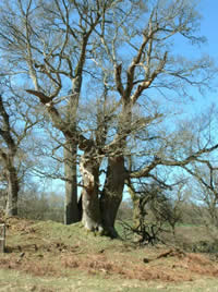
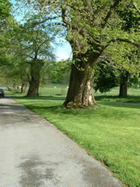
The veteran tree survey, carried out by Treeworks (Appendix 3) as part of the Conservation Plan, identified 295 ancient (predating 1600 AD) trees located throughout the estate including some in land belonging to the Wildlife Trust. Over 700 mature to late mature trees were also recorded. At the western end of the deer Park (Map 8 shows landscape compartments) there is a population of ancient maiden oaks. Some of these appear to be about 700 years old and therefore predate the creation of the Deer Park. These may have been deliberate plantings (though given the age this seems unlikely), natural regeneration following a mast year or the result of a catastrophic event such as fire or storm damage. They do not appear to have been managed in any traditional sense for over 400 years. On The Rookery a pre-existing scattering of oak trees dating to the 15 th century was surrounded with new planting as part of the 18 th century design. The line of six trees running approximately from east to west on the northern boundary of this area was found to date to around 1656.
Historic accounts, paintings and maps suggest that the family have maintained and protected their trees since at least the 17 th century. This explains the survival of such a large number of ancient specimens and how George Rice was able to create a park furnished with stands of mature trees.
Late medieval field boundaries and tracks discovered by Ken Murphy towards the western end of the deer park and in the Heronry can also be picked out from the veteran tree survey as they are marked by trees planted on or beside banks. These earthworks predate the creation of the deer park.
Early 18 th century paintings of the house and castle show stands or clumps of mature trees. Some these may be the early ancient trees mapped by Treeworks, possibly planted around 1600 when Sir Walter Rice was at the height of his power. They can be found in The Rookery and Cae lan and were later absorbed into 18 th century planting patterns.
 A line of sweet chestnuts marks the remnants of a formal avenue now enclosed within an 18th century plantation
Tree planting in the second half of the 17 th century was formal and straight lines predominated. At Dinefwr these were largely clumped and naturalised in the 18 th century but several hints remain. The drive built from the house to the Carmarthen road was marked with an avenue of alternating oak and lime 12m apart of which a few survive. A line or avenue of sweet chestnut was planted between the house and the castle. This was later partially removed and the remainder clumped. Three of the originals and a stump survive and now form part of a group, with oaks, to the immediate south-east of the house. There was a line of common limes along the western edge of the sunken track. Several of these still exist within later clumps at a distance of 7-7.5m apart. The second edition of the OS 25 inch map (1905) may depict a formal avenue along the north-west boundary of the park but insufficient trees remain to confirm this.
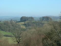
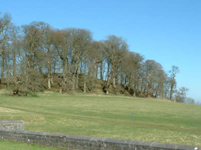
As was fashionable in the late 18 th century the Rice family chose to enhance the flowing parkland created to the east of the house with clumps of trees. Of the original six only four remain and two of these may have been reduced in size. The geophysical survey of the Roman fort shows ditches enclosing semi-circular plots adjoining the two clumps along the sunken track where now there are no trees. These two incorporate 17 th century limes but also include oak, beech and sweet chestnut. The dramatic beech clumps on Pen lan fawr, planted in the 1780s, have become important landmarks visible in all directions. From Newton House they frame views out towards the Black Mountains. The two clumps in the Outer Cow Park were removed in the 20 th century.
Groups and individual trees, possibly planted as early as 1600, provide the framework for the 18 th century planting design on The Rookery. As noted by Hal Moggridge ‘the edge is carefully shaped to draw fan-shaped space back into the wood at places where there are fine outward views'. Key points are marked with pre-existing veteran trees or by new planting of beech, sycamore, cedar and plane. In contrast the south-eastern edge was given a solid boundary by means of a line of oaks that echoed the more solid clumps further east in the park. The boundary between the two is almost imperceptible.
Additions in the late 18 th and early 19 th centuries include Scots Pine sited to pick out Fern Hill, Cae lan and the ridge close to the castle so that they would be visible in winter. Some of those on Fern Hill still survive. Isolated specimen trees were also planted throughout the park. Their location can be identified form the second edition OS 25inch maps.
Relatively few new trees were introduced in the 19 th century. Exotic conifers were planted near the house and beside Bog Wood, all in locations that do not detract from the original design. Only one of those planted close to the house survives. A small collection was planted at Cae Genvie north of The Rookery but this was largely destroyed in the 1970s. Between 1885 and 1905 several plantations were made to improve the shooting. This pattern of small scale additions together with some felling continued through the 20 th century and is well documented by Hal Moggridge on the basis of notes provided by Lord Dynevor.
Landscape Components- Spaces and Designs
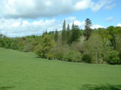
Within the park there are two types of spatial composition . To the west and south west open spaces are enclosed with continuous woodland and if the ground was flat there would be no outward views. In contrast to the east there are wide vistas over gently rolling landforms towards distant hills with trees confined to regimented clumps. These two variations meet at Newton House which acts as a focus for both. Some inter-mingling occurs with White Gate and Church Woods extending the ambience of Castle Woods towards Llandeilo and the smooth edges of the eastern part of The Rookery blending gently into the more rugged western boundary. The success of this design that apparently incorporates both the naturalistic and the picturesque can be attributed to George Rice and his wife Cecil who had the vision to maximise the potential of both the topography and the mature trees.
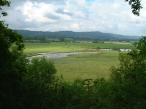
All the drives, principal walks and views are still visible and are described, illustrated and mapped in detail within the designed landscape survey and the topographic survey (Map 7). George Rice took full advantage of the medieval castle silhouetted against the southern sky but many of the views look out of the park, either towards the Black Mountains or along the Tywi valley. East Drive was, and still is, the main entrance. It was cleverly laid out to give snatched views of the castle through breaks in the woodland and has a dramatic swing that suddenly brings the house into sight. Similar views were also available from the Southern Drive though at a lower level. The Northern Drive climbed up over The Rookery with the house and landscape beyond appearing as the ridge was crossed. The route along the sunken track and downhill past the Slaughter House towards Mill Pond are thought to be service tracks.
Landscape Components – Structures and Buildings
The Roman Fort in the Outer Park has no visible surface remains though occasional pieces of brick appear. The possible Roman bath house is located in Brick Field and even today small pieces of Roman brick are easily retrieved where the structure is thought to be located.
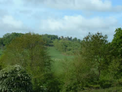
Dinefwr Castle dominates the landscape and is visible from both inside and outside the park. An icon of Welsh nationalism, it has an illustrious medieval history augmented by stories of a great and noble past. Unlike many of his contemporaries George Rice and Cecil Talbot did not have to resort to an artificial ruin to set off their new park but had the benefit of a genuine castle. It features in all most all the early descriptions of the park and was frequently sketched and painted.

Llandyfeisant Church was largely rebuilt in the 19 th century, possibly to a design by R. K Penson, but a medieval foundation is assumed and there may be an association with the Welsh town (Map 14). Nearby are three ruined structures one of which is a house abandoned in 1961 and the other two outhouses. In 1773 a new wall was built around the church yard and following the creation of the lower park it became an eye-catcher.
The existing Newton House was first constructed in the classical style in the middle of the 17 th century on three storeys, with walls arranged around a thick, spinal wall and central open-well staircase. The irregular fenestration on the rear elevation may be evidence that the earlier Tudor house was incorporated into this structure but surveys carried out when the house was refurbished failed to identify any evidence of sub-medieval masonry. The interior was renovated in the 1720s when the diagonal turrets may have also been added, though other sources suggest that they date to the middle of the century. The stone tile roof was replaced with slate in the early19 th century. In 1856 R.K. Penson encased the house in limestone from the Forest of Dean to a Venetian-gothic design. A port cochere was added to the front and a two storey conservatory to the rear. The billiard room was added in 1896. Elements of fine 17 th and 18 th century interiors survive including joinery and plaster ceilings. There is an oak-trussed roof with morticed purlins. Finds recovered during ceiling conservation included fragments of 17 th century documents and a mummified cat though to have been deliberately placed beneath the floorboards.
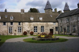
The Courtyards to Newton House are constructed in a figure-of-eight layout to the south-west of the main house. The northern or inner courtyard, built in about 1720, apparently incorporates at least one of the farm buildings shown on the early 18 th century paintings. Within the north-facing wall are distinctive round windows still visible today. An underground ‘special' passage was constructed to link the inner courtyard, which contained the kitchen, to the house and thereby preserve the sense of Newton being isolated within the park. The southern or outer courtyard was constructed in 1770. Built of random rubble, the ranges include both one and two storey structures all with modern tiled roofs. In the 18 th century they were screened by ornamental planting and do not appear on contemporary images. The north facing range may have been visible from the rear of the house. Dairy Cottage is picturesque-gothic and dates to the late 18 th or early 19 th century. All of these buildings are in private ownership.
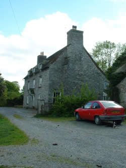
Home Farm, or Little Newton as it was known throughout the 18 th century, contains a farmhouse and variety of buildings including a threshing barn, cowshed, stable, carthouse/granary, general barn, fold yard and open-fronted stalls. Architectural evidence suggests the house dates to the first half of the century, possibly built around 1720 when the former farm buildings were incorporated into the Inner Courtyard. Documentary accounts record that the cow shed was built around 1755. These three buildings would have been grouped around a fold yard located to the front of the house and contained to the north by the park wall adjoining the public road between Carmarthen and Llandeilo. The farm was separated from the park to the south by a ha-ha and planting. The carthouse/granary, open stalls and a further fold yard to the north of the earlier yard were probably constructed in the late 18 th or early 19 th century as all the existing stone buildings are marked on the 1811 OS map. With construction of what later became the A40 the former public road was incorporated within the farm complex around 1810. Later an open-fronted barn was built across this line. Today the farm yard is dominated by four, steel-span modern sheds. All the historic buildings within the farmstead are constructed of random rubble sandstone under stone-tiled roofs arranged in diminishing courses. The battered base to the walls of the house and threshing barn, the elegant deep arched doorways into the cowshed and the inclusion of two threshing floors all point to a farm serving a significant estate. Opposite the farm entrance are two semi-detached houses, the Red Cottages, dating to the middle of the 19 th century. Built as ornamental estate cottages they are not in National Trust ownership.
Only one of the three gardens within the park belongs to the National Trust (Map 14). Laid out in 1856 the Fountain Garden to the rear of Newton House comprises formal beds and clipped yews surrounding a stone fountain all overlooked by a stone summerhouse built against a wall concealing the service courtyards. A ha-ha and wall separates the park from the garden. It was grassed over in the 1960s but restored in 1998 when the footings of a building shown on one of the early 18 th century paintings was discovered. The walled garden at Home Farm was built following instructions from ‘Capability' Brown. It has a curious clipped south-east corner as if it was altered to fit the loop of the park boundary. Most of the internal features have been removed and the outer walls have been seriously damaged. Both this and the garden beside Newton House are in private ownership. Brown asked that the latter be removed but ignoring this instruction the family turned it into a pleasure ground. The similarity between parts of this wall to the older part of the Deer Park wall suggests that they might be contemporary.
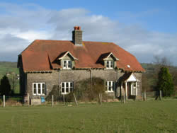
Pen parc , constructed between 1905 and 1911, is built in a distinctive estate style (Map 14). Originally a mirrored-pair of 2 storey cottages it has walls of rock-faced, snecked masonry of local stone and has a hipped roof covered with terracotta. The right-hand porch has been retained but the left has been removed and a new opening made in the gable wall. Internal walls have been removed to create new room spaces and connecting passages knocked through. The fittings are all modern though some of the original joinery has been retained.
East Lodge, South Lodge, Mynachdy , Kings Lodge and several farm cottages were built between 1880 and 1911. Keepers Lodge, or Mynachdy as it is now known, and South Lodge are built of bright, red brick that clashes dramatically with the subdued tones of the 18 th century landscape. All are in private ownership.
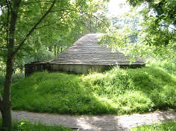
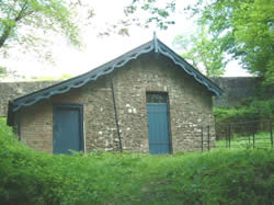
The Ice-House is located in the middle of The Rookery to the north of the house. The date of construction is unknown but it is not shown on the Tithe map of 1839. Most ice houses in Wales date to between 1750 and 1850. The brick chamber and dome are embedded in an earth bank and roofed with stone tiles. The narrow entrance passage consists of stone rubble with a flat, stone-slabbed roof originally sealed with a pair of doors. It has been recently repaired and the roof replaced. The Dovecot does appear on this early map but its age is unknown. Built of stone rubble it is octagonal in plan and lined with brick and slate nest boxes. Roofless, it is in private ownership. The walls of the Slaughter House, which was built in the late 18 th or early 19 th century, consist of partly coursed rubble with a slate floor. It also has been repaired by the National Trust.
There are three pump houses within the park, two beside Cold Bath Spring (Map 14) and the other below Mill Pond. Water was pumped to the house, garden, and to underground reservoirs and fire tanks on The Rookery. All three have a similar architectural style with stone rubble walls, gable roofs and carved and moulded barge boards. Two were constructed in the middle decades of the 19 th century and the third between 1885 and 1905. The pump house at Mill Pond was extended during the Second World War and contains an overshot wheel, a Bamford No 3 pump and an engine manufactured by The International Harvester Company, Chicago.
The presumed site of the 18 th century Cold Bath consists of a brick tank some 2m deep framed by an L-shaped wall containing a steel door behind which is a spring. Above, and separated by, an overgrown terrace is a semi-circular, fragile retaining wall. Bathing in cold baths was a popular 18 th century entertainment and ‘Capability' Brown's recommendation that this area should be enhanced with pleasure grounds implies that it was in use at the time (1775). Late 19 th century letters record that it was still known as Cold Bath Spring some hundred years later.
Crossing the stream beside the western boundary of the park are two small, stone bridges, without parapets, that are only visible locally. As they are part of the late 18 th century network of paths they are assumed to date to the same period. The stone culvert above Llandyfeisant church is a good example of 18 th century road engineering and is not part of any view.
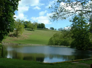
North Heronry Dam no longer holds water but originally ensured a constant flow down the little ravine to the south and is assumed to be part of the 18 th century, ornamental landscape. A carriage drive also ran over the top. Mill Pond Dam, in contrast, has been recently repaired and is part of the network of modern paths. A second, greatly-ruined, dam above Mill Pond has been assigned to both the 18 th and the early 20 th century but, whatever the date, it was undoubtedly constructed to counteract rapid rates of silt deposition, evident from map records and still a problem today. Mill Pond is conventionally associated with the medieval mill thought to have been located on approximately the site of the Victorian pump house. Early 19 th century maps show an L-shaped expanse of water but by 1885 this had contracted to the approximate outline of the present pond. Hal Moggridge states that the wet wood above this pond was clumped in the 18 th century. He further suggests that the ponds adjacent to the car park (but not in National Trust ownership) were associated with the medieval, English village.
The oldest walls are those surrounding the Deer Park. The wall between the house and the north-east corner was removed in the 18 th century and the section running through bog wood allowed to decay. Several stretches have been repaired and rebuilt but others, particularly those with a triangular coping, appear to be original. A short section of park wall was added to the northern boundary in 1748 and then the rest, linking the oak and lime avenue to South Lodge, was built at great speed in 1773. Part of this fell down in the 1930s so there is now no wall between Home Farm and Pen Parc. A new entrance and splay was created in the east-facing wall adjacent to the Rugby Club in the 1970s.
The remains of ‘Tin Town', the World War II hospital , are visible as scorch marks during periods of drought. The footings of these buildings were surveyed and covered with soil in the 1990s as they detracted from the 18 th century appearance of the park.
The Dynevor Collection
The pictures at Newton House represent only a proportion of the original collection of portraits and views. The major part was lost to the house and family when the 4 th Baron died leaving only daughters, the eldest of whom, who had married Captain Edward ffoliot Wingfield, inherited them. They are now at Barrington Court, Gloucestershire. What remains is of considerable interest and significance. Foremost amongst them are two pairs of views, of The Ruins of Dinefwr Castle, and of Newton House, respectively. Though probably of the early 18 th century rather than of c.1670 as they have customarily been dated, they are still amongst the earliest view paintings of what was briefly a distinct Welsh school. The oil paintings include two fine Knellers; a very early three-quarter length of John, 3 rd Lord Lovelace (c 1638/42-1693) , and a late whole length of William Talbot, Bishop of Salisbury(1659-1730) ; a Vanderbank of Charles, 1 st Baron Talbot (1685 –1737) as Lord High Chancellor; a Ramsay of Mary de Cardonel, Countess Talbot ; and a rare Gavin Hamilton of 1754 (i.e. before his return to Italy) of the great entrepreneur Thomas Keymer of Kidwelly (1722-1784), dressed a la chinoise. The pastels include a Hoare of Bath of The Rt. Hon. George Rice (1724-1779), still with an inscription on the back recording the payments of its carriage from Bath to Sackville Street; and the one survivor at Newton House of a charming and a well framed set of pastels apparently of his children called The Hon. Maria Rice, later Mrs Markham . There are 22 family portraits in all.
Landscape Components – Habitats and Ecology
Mature and veteran trees in the deer park and other parts of the estate such as Castle Woods (Map 8) support large numbers of important lichen. Over 160 species of lichen have been recorded including Catillaria atropurpurea, C pulverea, Lecanactis spp, Schismatomma niveum and Thelotrema lepadinum all indicative of woodlands with a long history of ecological continuity . Also present are Lobaria pulmonaria and Stricta limbat . These form the characteristic epiphytic community of mature oak forest in the UK. It is sensitive to atmospheric pollution and so largely confined to western Britain and Ireland. The Red Data Book species, Collema fragrans has been recorded but this is usually dependent on the nutrient rich bark of trees such as elm so is declining because of Dutch Elm Disease. Other scarce species include Gyalidiopsis musicola, Phyllopsora rosei and Lecidea doliformis.
The trees also host a remarkable community of saproxylic (dead wood) invertebrates, mostly beetles. In all there are at least 26 Nationally Scarce species. Ptinella umbata has its only Welsh locality at Dinefwr. Important invertebrates are also found in the tufa flushes associated with the springs at the western end of the park. As is typical of wood pasture habits the ground flora is poor.
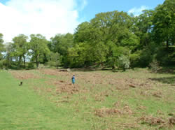
Within the Deer Park the semi-improved neutral grassland approximates to a knapweed-crested dog's tail (Centaurea nigra – Cynosurus cristatus) community though it is not a particularly rich example. Extensive areas of ant hills demonstrate ecological continuity of land use. These belong to the yellow meadow ant ( Lasius flavus) and are a good indicator of old grasslands. These attract one of several bird species that are typical of old parklands, the green woodpecker, which is myrmecophagus. Bracken covers large areas. Comparison of aerial photographs taken in 1971 with today suggest that it has increased dramatically in recent years.
The seven oxbow lakes support a typical range of aquatic and emergent plants but include local species such as lesser marshwort ( Apium inundatum), nodding bur marigold (Bidens cernua) and bladderwort ( Utricularia australis ). Recent surveys have identified over 4000 different macro-invertebrates including the freshwater limpet Tinodes unicolor. The lakes are particularly important for wintering wildfowl. The invertebrate population includes one Red Data Book species, Callicera aenea. The hedgerows in the Tywi valley support a breeding population of the tree sparrow, a rare and declining farmland bird. The population using the Dinefwr estate hedges is the subject of a long-term study using nest boxes. This is being carried out by a National Trust volunteer.
Bog Wood is secondary in origin. This alder-creeping jenny-ash ( Alnus-Lysmachia-Fraxinus ) community also supports rare lichens.
Castle and Church Woods are structurally diverse supporting a range of plant communities and invertebrates indicative of ancient woodland status. 200 species of higher plants have been recorded and 15 species of lichen. The invertebrate population includes the red data species Rhyngia rostrata .
The built structures, walls and quarries also support several notable species. Of particular interest is the use of the estate by bats. Recent surveys have revealed at least six species including the serotine bat which is uncommon in Wales. Brown long-eared bats breed in the roof voids of Newton House
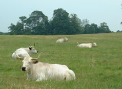 White Park cattle
The herd of White Park Cattle are the descendants of a herd associated with Dinefwr since medieval times. White Cattle feature in medieval Welsh texts. The laws of Hywel Dda, a 10 th century leader of Deheubarth, refer to fines and payments recovered with white cattle. Several of these ancient breeds were emparked in the 13 th , 14 th and 15 th century including the Dinefwr herd though the actual date is unknown. By the 1960s only four of these herds remained though, since the 1970s, new herds have been established. In 1930 there were 68 animals at Dinefwr but numbers fell gradually until, in 1951, there were only 13. When Lord Dynevor broke up the estate in the 1970s he also sold the herd. The National Trust was able to buy back the direct descendants of these animals in 1993 and now has 18 animals.
A herd of fallow deer occupy the deer park.
Culture and Community
Like all other nations, the history of Wales commemorates the deeds and influence of a sequence of remarkable people. Two of these lived here at Dinefwr thereby investing the castle with an identity that has come to symbolise Welsh nationalism. Some of the stories associated with this site may be little more than legend generated to support the claims of others but now, with the passing of almost a thousand years, these merge seamlessly with actual events. There is, however, no doubting the achievements of The Lord Rhys and Sir Rhys ap Thomas. The former establishing what in later generations came to be described as a golden kingdom based on distinctly Welsh ideals. Sir Rhys was a king-maker who may not have directly effected Dinefwr but who raised the profile of his country.
The Rice/Rhys family occupied Dinefwr for over 500 years and created one of the most remarkable landscapes in Great Britain. Their admiration for the trees on the estate facilitated the creation of the park and also ensured that it continued largely untouched through to the 21 st century. The benefits of this continuity are reflected in the habitats and ecology of the park. The family served their county and community taking up political office though out the centuries. George Rice was a pioneer of the agricultural revolution, one of the first to introduce crop rotation to Carmarthenshire.
Dinefwr abuts Llandeilo. It is seen as a community resource, a place to be proud of that inspires a sense of well-being. It is visited regularly, sometimes on a daily basis. The inhabitants of the town take an active interest in the management and development of the estate. There was enthusiastic support for ‘The Dinefwr Appeal' launched by the National Trust in 1987 to raise funds for essential maintenance. Both the park and Newton House are used as venues for community events and a ‘Friends of Dinefwr ‘ was established in 1998.
Local volunteers assist the National Trust with stewarding Newton House when it is open to the public. The intricate beds in the Fountain Garden to the rear of Newton House are managed almost entirely by volunteers. Maintenance projects within the wider park are undertaken by both local residents and by parties of volunteers organised through the Trust's national volunteering scheme. The Wildlife Trust South and West Wales rely on their network of local volunteers to manage Castle and Church Woods.
Dinefwr has served as a focus for countryside skills. Local government training schemes have operated in the park, most recently New Deal. Property staff continue to encourage and support partnerships with organisations such as the Probation Service, the Pembrokeshire and Derwen National Health Service Trust, the Carmarthenshire Youth Service and others. Links have been recently established with the Duke of Edinburgh Award scheme and with the Open University.
Recreation
The residents of Llandeilo and the surrounding area use the eastern part of the park as a recreational resource. They walk in along the Eastern Drive, often as far as the car park, and return along the same route. Those wanting a longer walk return via the South Drive through The Wildlife Trust South and West Wales woodland. There is permanent access to this part of the park but the deer park is only open on the days advertised in the hand-book.
National Trust visitors who pay to visit the property have travelled specifically to visit the house, castle or Deer Park. A significant proportion confine their interest to built structures and interiors and the facilities provided for a conventional day-out. No charge is made to pedestrians visiting the Park, the Castle or the Wildlife Trust's woodlands. Visitors to the Castle pay to use the National Trust's car park but there is a free disabled car park adjacent to the Castle.
Statutory Designations
- Scheduled Ancient Monuments
- Dinefwr Castle
- Listed Buildings (Map14)
- Dinefwr Castle (Grade I)
- Newton House (Grade II*)
- Inner Courtyards (Grade II*)
- Outer Courtyards (Grade II*)
- Summer House (Grade II*)
- Newton House Walls and Gates (Grade II)
- Dairy Cottage (Grade II)
- Dovecote (Grade II)
- Ice House (Grade II)
- Slaughter House (Grade II)
- Llandyfeisant Church (Grade II)
- Dynevor Home Farm House (Grade II)
- Dynevor Home Farm Barn (Grade II)
- Dynevor Home Farm Byre (Grade II)
- Sites of Special Scientific Interest (Map 3)
- Dinefwr Estate (ecology and habitats)
- Dinefwr Estate (geology)
- cSAC
- Afon Twyi (Fish - Twait Alis and Shad)
- Register of Landscapes of Outstanding Historic Interest in Wales
- Twyi Valley
- Register of Parks and Gardens (Map 3)
- Dinefwr Park (Grade I)
- Conservation Area (Map 3)
- Llandeilo