Dinefwr Park
Understanding (I)
Methodology
The wide range of studies and surveys undertaken prior to the establishment of The Dinefwr Project include histories of the castle, family, landscape and house; building and structural surveys; ecological and habitat surveys and archaeological surveys. The National Trust maintains an estate archive at the property. Cadw retains copies of archaeological surveys of the castle at Cardiff and the Wildlife Trust South and West Wales hold copies of surveys carried out on Castle and Church Woods at their offices in Cilgerran. By the beginning of the 21 st century the development of the estate and its significance was understood in general terms. Key documents include a landscape survey undertaken in 1989 comprising the ecology and the history of the park (Appendix 1); Cadw's guide to the castle; a management plan produced for Castle Woods and a detailed survey of Newton House written whilst the house was undergoing refurbishment. However, the National Trust, Cadw and the Wildlife Trust decided that this body of work fell short of what was required to assess threats and devise policies that would adequately protect the park
By means of resources made available by the Heritage Lottery Fund as part of The Dinefwr project new surveys were commissioned by the National Trust. These included:
- designed landscape survey (Colvin and Moggridge, Appendix 2)
- veteran tree survey (Treeworks, Appendix 3)
- archaeological survey (Salvatore Garfi, Appendix 4)
- building surveys (Muckle Partnership, Appendix 5 and 6)
- geophysical surveys (Stratascan and Cambria Archaeology Appendix 7)
- Lancelot Brown at Dinefwr (Debois Partnership)
- topographic survey (Cambria Archaeology,)
- building surveys (Cambria Archaeology)
- freshwater biology (Tony Jenkins)
It was intended that these would focus on key concerns but all, especially archaeology and veteran trees, produced completely unexpected information. This gave rise to a further set of questions, which will be addressed as part of The Dinefwr Project Phase Two An integrated approach to information gathering was adopted by means of regular meetings between the contractors, property staff and advisers.
Geology
The geology of Dinefwr Park consists of Ordovician rocks of the Llandeilo series formed some 470 million years ago. These fossiliferous strata take their name from local outcrops known to geologists for over two centuries. The fossils were part of a seabed animal community that included trilobites and brachiopods typical, and special, to the Llandeilo series. Rocks of the same Llandeilo type can be recognised everywhere they occur on the basis of the distinct fossil communities. Within these layers of sandy flags are occasional bands of impure limestone. Quarries and natural exposures have allowed geologists to trace the entire sequence of this series within the park. The quarry to the north of The Rookery has a particularly high fossil content. The Tywi valley is an eroded anticline with a north-easterly dip to the north. Several soil types have been identified. The Denbigh series covers most of the park. The Teme, Llandeilo Alun and Tywi series cover the meadows. Water logged soils in the Heronry, south of Home Farm and in Castle Field, belong to the Cegin series. Sannan series are scattered throughout. Bog Wood consists of the Freni series and there is a small strip of Ty-Gwyn along the base of Castle Wood ridge.
Topography
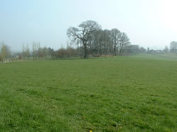
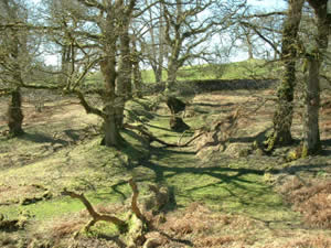
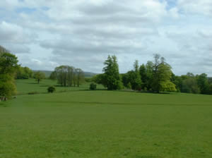
Abutting the meandering Afon Tywi, which provides the southern boundary to the property, are level meadows. Oxbow lakes at the western end reflect the changing course of this river and the fields at the eastern end flood in winter. A series of wooded ridges divides this part of the park from the higher ground to the north. At the western end of the property these ridges continue northwards creating a dramatic landscape of rugged groves of mature trees interspersed with unimproved pasture. The more gentle undulating topography that characterises the remainder of the park is divided into large fields separated by mainly modern field boundaries.
Prehistory and Roman Occupation
Evidence of prehistoric activity in Dinefwr prior to the recent surveys consisted of stray finds and speculation as to what might have preceded the stone castle given its strategic location. A presumed prehistoric hammerhead was found in a pool on the edge of the park. During the construction of the by-pass two flint flakes were recovered and a possible ring ditch recorded. In 1876 a neolithic, polished, stone axe-head was found near Newton House. Confirmation of prehistoric activity was discovered during the recent topographic survey of the deer park when an Iron Age, promontory fort and possible burial site were recorded (Map 6).
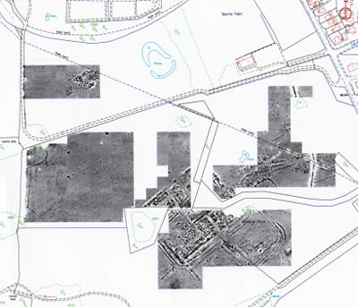
Occasional finds hinted that there was a high status Roman settlement located somewhere within the park. Geophysical survey carried out as part of the conservation plan confirmed this recording two overlapping forts together with a vicus, roads and possible bath house. This discovery has solved a long-standing gap in our understanding of the conquest of this part of Wales. Llandeilo is half way between the forts at Llandovery and Carmarthen. Given the regularity of the intervals between Roman military installations it was presumed that there was another fort close to or within the town though the presence of two structures was entirely unexpected. The older and larger of the pair may have been constructed shortly after the Romans first arrived in 74AD. Unrest further north may have forced a temporary withdrawal; the soldiers returning later to set out a smaller fort. Alternatively this archaeology may reflect an as yet unsuspected chapter in the conquest of Wales. The remarkable quality of the geophysical survey suggests a high degree of preservation but all is concealed beneath the turf and as yet there is no indication as to the character of the archaeology.
Early Medieval Dinefwr and the Legacy of the Lord Rhys
When analysing the early medieval history of Dinefwr it is difficult to define where myth and legend cease and history begins. It is certain that Llandeilo was a monastic centre associated with Teilo, a sixth century saint. The town may have been the site of his clas , or mother church and he may have been buried here. Two carved stone cross heads still preserved within the church indicate that this community survived through to the ninth or tenth century. Texts dating to later in the medieval period describe Dinefwr as the capital of Deheubarth, one of the early medieval kingdoms of Wales, but this is not supported by archaeological evidence. Nothing so far discovered by Cadw links the castle to early kings such as Hywel Dda (d.949-50) or Rhys ap Tewdwr, or supports the later medieval claim that Dinefwr was equivalent to Aberffraw, the chief court of the kingdom of Gywnedd. It is not mentioned in the Welsh chronicles based on Brut y Tywysogyon or in any other historical sources any earlier than the 12 th century.
It was the emergence of the Lord Rhys, Rhys ap Gruffudd, that secured the role of Dinefwr in the history of Wales. Whatever the antecedents, by the end of the twelfth century, the castle had come to symbolise the historic might of medieval Wales. It is possible that, as suggested by Ralph Griffiths, this image was deliberately enhanced by exaggerating the antiquity of the site.
Rhys ap Gruffudd overcame the power of the Anglo-Norman lords and reinstated the kingdom of Deheubarth becoming one of the most admired leaders in the history of Wales. Dinefwr is first mentioned in the chronicles in 1163 when Rhys submitted to Henry II at Pencader and was granted Cantref Mawr and land at Dinefwr. He went on to control an area which encompassed most of south west Wales, all ruled from his power-base at Dinefwr. Given that Norman control had been imposed and rigorously upheld since 1093 this was a remarkable achievement though he did have the tacit support of the crown. Historical accounts have left us with a picture of a cultured, confident man comfortable with his position within Wales. He was a military realist who confined his aspirations to the boundaries of Deheubarth but extended his influence through the tactical marriages of his children. He encouraged Welsh traditions and religious affairs and facilitated a stable, peaceful administration. Dinefwr still echoes with resonances of this golden era.
Unfortunately after his death in 1197 his sons and grandsons squandered his legacy. Deheubarth was divided, and endless squabbles saw Dinefwr exchanged backwards and forwards between different members of the family. Eventually in 1216 after the intervention of Llywelyn the Great, Prince of Gwynedd, Rhys Grug, his second son, inherited the castle together with a third of the kingdom. Upon Rhys Grug's death in 1233 internecine fighting started afresh and continued for several generations with the crown intervening from time to time to demand homage and to provide occasional military support. This situation was not resolved until Edward I conquered Wales in 1277. Rhys Wndod, great, great grandson of The Lord Rhys submitted to the king and succeeded in retaining most of his estate though Edward, recognising the symbolism of Dinefwr, transferred the property to the crown. It remained under the control of a royal constable until the 15 th century. The rise of Owain Glyndwr in the first decade of the 15 th century gave renewed hope to Welsh ambition. In 1403 his army reached the Twyi valley and besieged Dinefwr for ten days. Eventually it was the Welsh who withdrew though it was a further three years before the crown regained full control of the area.
The Development of Dinefwr Castle
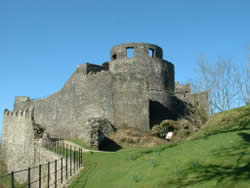
Excavation and intervention within the historic masonry at the castle has been on too small a scale to allow the discovery of structures dating to before the second half of the 12 th century when the Lord Rhys was at the height of his power. The strategic position of this rocky crag has given rise to frequent speculation as to age of the castle but as yet no evidence of earlier occupation has come to light. Two earthwork enclosures set side by side along the ridge and protected by a deep rock-cut ditch are almost certainly original but it is not clear whether it was the Lord Rhys or his son Rhys Grug who embellished these with the first masonry curtain-wall. Sian Rees suggests that given the status of the Lord Rhys it seems more likely that he was responsible. The great circular keep belongs to an architectural form conventionally dated to about 1230 and may, with some confidence, be assigned to Rhys Grug. Archives record that alterations and additions continued when the castle was transferred to English control with the last major work occurring in 1326 when the hall, western building and new windows were added. Some repairs were carried out after the Owain Glyndwr siege but there are also contemporary accounts describing the ruinous state of the castle. It was finally abandoned in the 16th century. In the late 17 th century a summer house was built on top of the keep and the southern turret re-roofed but by the late 18 th century the site was once again a ruin. The Dynevor family maintained the site throughout the 19 th and 20 th centuries, using estate staff to rebuild fallen masonry, erect safety hand rails and install furniture and weather proofing to prospects or as shelter.
Tons and trees – the medieval landscape
During the 13 th century a small township – later known as the Welsh town – developed outside the walls of Dinefwr castle. To consolidate the influence of the crown a second township in the form of an English colony was established sometime after 1277. By the beginning of the 14 th century there were two adjacent towns, three if Llandeilo is included. English constables kept detailed records throughout this period permitting some insight into the development of this congested, medieval landscape. In 1360 Newton had 46 burgages but the less successful Dinefwr had only 25 house plots. There was also a mill. Hal Moggridge's map gives an indication of the extent of this occupation though the layout and location are conjectural. Some three years later Newton became a chartered borough. A series of further grants suggest that it remained a flourishing community through to the beginning of the 15 th century and that the Welsh town of Dinefwr was deliberately disadvantaged. The rents in 1394 were the same as in 1360.
No archaeological evidence of either of these towns survives as surface features. On the basis of historic records and accounts describing Newton House as located within the town of Newton it has been assumed that the present house sits within the English colony. Richard Fenton in1804 refers to the daily recovery of fragments of buildings to the west of the house. One of a series of four early 18 th century paintings show land boundaries remarkably similar to burgage plots. In the 1530s John Leland described Newton as ‘sumtime a long street nowe ruinus'. The Welsh town was probably established close to the castle and may have been similar in plan to that recorded at neighbouring Drwyslwyn Castle. Hal Moggridge has argued that some of the tenants described in a 1360 schedule lived below the castle on what was originally demesne land. This may account for the isolated location of Llandyfeisant Church. Some ephemeral earth works beneath the trees to the east of the castle may be the remains of fields or gardens associated with this town.
Recent surveys have hinted at the nature of the wider medieval landscape surrounding these towns. Topographic and archaeological surveys have identified tracks and fields boundaries that apparently pre-date the creation of the Deer Park (Map 6). Several routes cross the park with two running beneath the park wall. Some appear to focus on the castle and others on Newton. It is assumed that these were in use during this period though it is also possible that they were created many centuries before. Low earth banks have been discovered within the Deer Park including enclosures approximately 8 acres in size. As this is the amount of land allocated to English settlers in 1298 (one Welsh acre) it has been suggested that this might represent one of the 13 th century plots. However, this may be nothing more than a coincidence as English occupation of Wales during this period is generally associated with open-field systems where unenclosed-strips of land were divided amongst the villagers on an annual basis. 17 th century surveys describing Rice land as intermingled with that belonging to their neighbours appears to confirm the existence of an earlier open-field system. It is also likely that this system had broken down into individual fields before the Deer Park was emparked, a late-medieval process well-documented in other parts of Wales.
The advent of the Rhys family
In the first decades of the 15 th century Dinefwr passed back into Welsh control, though nominally Sir Roland Standish was still the constable. Gruffydd ap Nicholas was a member of a respected Welsh family who gradually acquired extensive lands in Carmarthenshire and Ceredigion and was trusted by crown officials to carry out administrative duties. A 17 th century description records that he was ‘infinitely subtle and crafty, ambitious beyond measure'. Although he and his family were temporarily deprived of the castle and lands during the Yorkist period of the Wars of Roses, Gruffydd's aspirations succeeded in that his descendants retained control, and then ownership of Dinefwr for the next five centuries.
The famous Sir Rhys ap Thomas was Gruffydd's grandson. As a reward for assisting Henry Tudor in his invasion through Milford Haven Rhys was knighted and became justicar (viceroy) of South Wales. Although his main residence was at Abermarlais Sir Rhys maintained a house at Dinefwr, though whether the construction of the original Newton House can be attributed to him or his grandfather has yet to be clarified. As Sir Rhys had a ‘passion for parks and hunting' and ‘spent considerably on buildings and parkland' Hal Moggridge has suggested that he may have used Newton as a hunting lodge and perhaps created a park.
In 1531 Rhys ap Gruffydd, grandson of Sir Rhys, fell foul of Henry VIII. He was executed on five unsubstantiated charges of high treason and his property, including Dinefwr, forfeited by the crown. Although not to the advantage of Rhys, this greatly benefited posterity as a detailed survey of his houses and lands was carried out. At Dinefwr 30 tenants, holding 42 premises of various sizes, are recorded, a significant decline since the middle of the 14 th century. There is no separate mention of the Welsh town. Newton House lay on an east-west axis with eight chambers, including a ‘loo chamber' and a study at either end of a hall 33 feet by 20 feet. On the south side was a tower and chapel, kitchen, larder and buttery. There was a wine cellar beneath the hall and nearby a brewhouse and ‘backhowse' with a corn store above.
Consolidation and acquisition
Gruffydd Rice, son of Rhys ap Gruffydd, devoted his life to restoring the family name and lands. Despite the setback of a conviction for a ‘shamefull murdre' in County Durham and as a result having the family property removed by the crown for three years, Gruffudd put in place a pattern of stabilisation and expansion that continued for the next three centuries. A survey of 1563 indicates that there were 28 dwellings in Newton/Dinefwr with 17 separate tenancies amounting to 123 acres. The castle had apparently been recently abandoned but it is assumed that the house was still in existence.
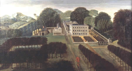
As soon as Sir Walter Rice inherited in 1592 he set about buying land, making some 85 purchases of burgage plots and messuages of which 40 were in the present-day park. He had the misfortune to have expensive tastes and accumulated large debts that had to be accommodated by his relatives in return for family lands in Pembrokeshire. Newton House and its demesne were leased to a tenant, and Henry Rice, his son, struggled to restore financial stability. Surveys carried out in 1622 and 1651 record that Newton House was surrounded by what remained of the original English town still mostly in the ownership of others and that Rice lands were interspersed with other holdings. The area around Llandyfeisant church and most of the eastern part of the later park were not yet coherent parts of the estate. The series of early 18 th century paintings of the park, house and castle show mature trees implying that they must have been in existence at this time (Figures 8&9).
By 1659 the castle had been joined to the remainder of the estate by purchase and an additional 7 properties had been bought in Newton and Llandyfeisant. The tenant was removed from Newton House. Edward Rice had the public road between Carmarthen and Llandeilo diverted from running through the middle of Newton to the edge of what became the park boundary. It is likely that the original road is the hollow-way and track picked up by the topographic survey in the north-western corner of the park. Following this work began on the new house and possibly the Deer Park.
The Restoration Landscape – avenues and formality
It is generally assumed that the present house was constructed in the middle of the 17 th century but we have neither architectural, archaeological nor documentary evidence beyond the road diversion to confirm this. Our picture of Dinefwr in this period in based almost entirely on the set of four landscape paintings thought to date to the first two decades of the 18 th century. These show a house, farm, formal gardens, deer park, avenues, castle and clumps of mature trees. Elements of this landscape survived into the 19 th century and a few continued on into the 20 th century, sufficient to confirm that these paintings reflect the actual layout.
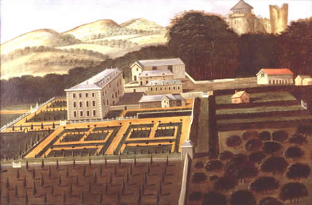
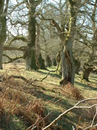
Formal lines of trees demonstrate that there was an avenue linking the house with the Carmarthen to Llandeilo road and another running south towards the castle (Map 4). A few of these trees still survive - limes and oaks to the north and sweet chestnut to the south and they also appear on early maps. There may also have been linear planting to the east and certainly there is today the remnant of a north-south line of limes that was later incorporated into clumps. Each of the four images also depict mature trees suggesting a heavily wooded landscape within the deer park and around the castle.
Two of the paintings show agricultural buildings to the rear of the main house, though the layout differs between the two so they may not be contemporary. The size of these structures implies a significant enterprise. Architectural evidence suggests that one of these buildings was incorporated into the present-day inner courtyard and wall footings discovered during the restoration of the fountain garden in the 1990s match the outline of another. With the exception of a piece of a medieval floor tile, all the finds recovered during a small-scale excavation of this structure are 17 th or 18 th century. Lack of stratification implies deliberate destruction, possibly when the landscape park was created. One of this pair of paintings depicts burgage plots, one containing a small house, to the west of these buildings.
To the north and east of the house the paintings record formal, Italianate gardens with pavilions and a canal. No evidence of this has survived and indeed its existence has been questioned. Watching briefs conducted during refurbishment of services to the house in the 1990s failed to uncover any evidence of this garden and a geophysical survey carried out in 2003 produced no conclusive images.
The age of the Deer Park is not known. Recent surveys have failed to identify when the walls were built but it was in existence when these paintings were created.
By the early decades of the 18 th century the castle had acquired a gazebo that afforded magnificent views over the park. This addition apparently reflects a desire to impress visitors with the quality of the park. The date of this structure is not known though the family did not acquire the castle until 1659. It appears to serve the same function (albeit on a much grander scale) as a mount. These raised hillocks were considered old-fashioned by the 1640s but several survived through to the end of the century. A small pavilion, shown to the west of the castle, has been variously interpreted as a bathhouse or a building shown on the first edition of the OS 25inch map that was later removed.
Although acquisition of land continued, in 1675, when Griffith Rice inherited, there were still parcels of land in different ownership within the vicinity of the house. He retained the park as he inherited it though in the 1720s he modernised the house by renovating the interior and creating the inner courtyard. Architectural evidence suggests that this range incorporated part of the Tudor quadrangle
The Naturalistic, the Picturesque and 'Capability' Brown
George Rice, who inherited from his grandfather, achieved his majority in 1745. Along with the Lord Rhys and Sir Rhys ap Thomas he and his wife Cecil Talbot are key to the history of Dinefwr. The family tradition of acquiring land was reinvigorated with the purchase of Park Harry (thought to be at the southern end of the original Newtown) in 1748. Over the next 30 years he continued to lease or purchase land to the east of the house.
Gradually all constraints to re-landscaping and creating a park were removed. Work commenced in the winter of 1757 with the removal of trees and hedges and the creation of clumps. Entries in account books reflect works necessary for the conversion of farmland into smooth, flowing lines. A new drive to Llandeilo was created and the fields in the lower park emparked. Home Farm was moved to its present location and the ‘trench' (sunken track), which probably marked the original boundary of the land in Rice ownership, converted into a service route. The design of this layout implies that George Rice fully appreciated the role of his ruined castle as the most important structure on the estate.
From W.S. Gilpin's enthusiastic account, written in 1770 but published in 1782, it is clear that significant areas of parkland had been created by this date. The formal plantations and farmland east of Newton House had been moulded into naturalistic parkland. and existing tree cover altered and enhanced. He comments particularly that there are only a few young plantations. Gilpin was one of the forerunners of the late 18 th century picturesque movement and because of his writings Dinefwr became one of the most fashionable parks in the country.
Accounts dating to 1773 refer to the construction of the park wall from Pen-parc to Llandeilo Bridge, some of it at great speed as 15m a day was achieved. The collapse of the section between Pen parc and Home Farm in the 1930s implies a lack of stability.
When Lancelot 'Capability' Brown was invited in 1775 to give his opinion the basic framework of the park had been set out. Lawns swept up to a house that was set against a backdrop of mature trees. Service buildings were screened by ornamental planting and linked to the house by a special ‘passage'. A model farm had been established well away from the house and all formality removed. Obviously impressed, he wrote to George Rice ‘I wish my journey may prove of use to the place, which if it should, it will be very flattering to me. Nature has been truly bountiful and art has done no harm'. Brown was not required to produce a plan but he did advise on a series of additional works. As directed the kitchen garden was removed to Home Farm and a shelter belt planted between there and Llandeilo along the ha-ha and park wall. The entrance was moved to its present location, though the gothic lodge and gate designs drawn up were not implemented. Llandyfeisant meadows were thrown together but not until the 1790s. On the basis of an image dated to 1777 Hal Moggridge has argued that Brown's suggestion that Bog Wood be divided into three clumps was heeded. He also required that the Mill Pond head be destroyed but this did not happen. Likewise the suggestion that the lawns near the cold bath be enclosed for a pleasure ground with a pale were ignored. Instead the walls of the kitchen garden by the house were not demolished as recommended but the area converted to an ornamental layout. The wall between the house and the Carmarthen road was replaced with hurdles and realigned to the proposed new doors though late 18 th and early 19 th century paintings indicate that these hurdles were not made to Brown's design. He also laid out a path that can be traced on the ground today. It is shown clearly on 19 th century maps running through The Rookery, across Mill Pond Head, past the castle and back across ‘lawns&rsquo along the approximate route of one of the formal avenues that had been recently clumped.
The implementation (or non implementation) of these instructions can be confirmed by what survives and what appears in contemporary images and 19 th century maps. Some inconsistencies remain. Capability Brown refers to the bath house but the date and appearance of this building is unknown. Field observation suggests that this may have been located beside a spring near the western boundary of the park and certainly this fits with the Brown description. There is a building with a portico shown in the early 18 th century paintings in approximately the correct location but this is a very early date for a bath house, a structure more usually associated with the latter half of the century. Hal Moggridge believes that this may be the structure shown to the north of the spring on the early editions of the OS 25 inch maps but there is no supply of water at this spot. Earlier maps at a smaller scale mark the bath house at both this location and at the spring. Family archives refer to testing the water at Cold Bath Spring. Several paintings show deer to the east of the house suggesting that the deer park was extended as far as the sunken track. Hal Moggridge has argued on the basis of fences shown in other images that in reality this may not have been the case.
George Rice died only four years after Brown's visit leaving a fourteen year old son who lived until 1852. In 1782 he became the 3 rd Lord Dynevor on the death of his maternal grandfather, who had been created 1 st Baron Dynevor to descend through the female line. During this time the northern drive was realigned to the west to pass through what subsequently became known as the Brown Doors, though whether this is because of the colour or the person remains unclear. The present-day doors are, in the opinion of Hal Moggridge, mid 19 th century, including the piers. The drive continued northwards to meet the new Carmarthen road recently diverted from its original route beside the park wall. This was reduced to the status of a farm track as it still is today. There are many other picturesque walks in the park. When they were created is uncertain but a late18 th century date seems likely. Pen lan fawr was emparked and crowned with clumps that are recorded as new plantations in sketches produced by JM Turner in 1798.
The park attracted numerous travellers many of whom recorded their favourable impressions. Writers include Fenton, Malkin, Clutterbuck and Lipscombe amongst others. An image of the park also appeared on a Wedgewood dinner service created for Catherine the Great. The maturity of the trees is a common theme, often described as ‘venerable,' with Richard Fenton indicating that they were unrivalled and Thomas Roscoe suggesting an ‘ancestry co-eval with the fortress itself' but the park probably did not achieve the potential envisaged by George Rice until the early 19 th century (Map 5 and Map 7).