Llandeilo’s Roman Fort
In 2003 an exciting find was made in the grounds of Dinefwr Park which may in time eclipse even the Medieval castle in importance. It has long been known there was a Roman fort somewhere in Llandeilo: the question about its existence has not been if but where. The Romans built forts every fifteen miles or so to enable their troops to be deployed swiftly in case of local disturbances. There is a Roman fort in Llandovery and another one thirty miles west at Carmarthen, so there had to be one in Llandeilo, equidistant from both. It had been thought that Llandeilo's fort would be nearer the river Towy, but four dinari (Roman coins) found in a field on the Dinefwr Estate shifted the search further inland from the river bank.
Gwilym Hughes of the Cambria Archaeology Trust, the body responsible for the archaeological heritage of West Wales, writes in the Summer 2003 edition of their newsletter, Cambria Archaeology:
During an archaeological survey commissioned by the National Trust of their estate at Dinefwr Park Llandeilo, the exciting discovery of a Roman military fort was made by Stratascan, a geophysical survey team used by Cambria to assist in the survey. This work has been supported by the Heritage Lottery Fund.
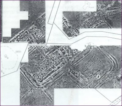
A geophysical survey produces a radar-like picture of features beneath the ground surface. What is even more exciting about the Llandeilo find is that there appear to be two forts on the same site, as well as a civilian settlement and other related features, including a Roman Road and a possible Roman bathhouse site. It is thought likely that the first fort dates to about AD 74, the time of the Roman conquest of Wales. [The Romans landed in Britain near Dover in AD 43, so they had reached Llandeilo in just 30 years]
It has a possible area of 3.9 hectares, which would make it one of the largest Roman campaign forts in Wales and may have housed a Roman legionary detachment. A second, smaller fort seems to have been built on the same site after the conquest and a small settlement grew outside its gates. The shadow of the first fort can be seen in the lower half of the image produced by the geophysical survey (below). The settlement outside the gates can also be seen in the upper right-hand quarter of the image.
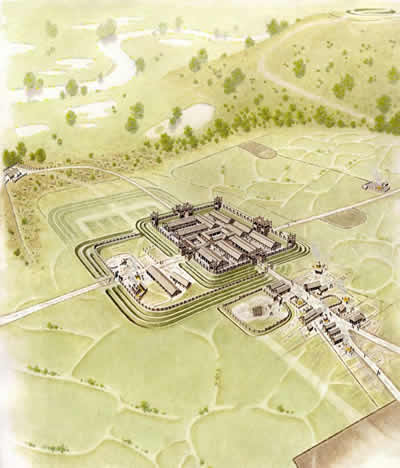
An idea of what the fort might have looked like can be seen in the geophysical survey and an artist's impression below.
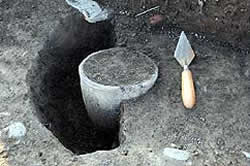
From June to July 2005 a three week archaeological dig of the Roman fort was undertaken as part of Channel 4's 'Big Roman Dig' TV project. On the first day a first century AD funeral urn was discovered (see photo left).
The dig also confirmed the findings of the geophysical survey that there were two overlapping forts plus a vicus, or civilian settlement, dated from 75 AD to 120 AD. For more details of the July 2005 excavation see the Cambria Archaeology newsletter (PDF).